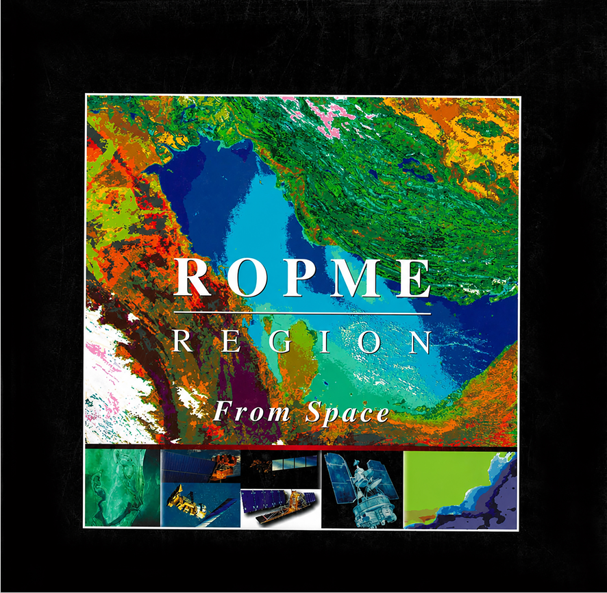


The ROPME From Space Atlas is one of the flagship scientific initiatives launched by the Regional Organization for the Protection of the Marine Environment (ROPME) to develop a comprehensive environmental information base for the ROPME Sea Area (RSA) through the application of remote sensing technologies and satellite imagery.
The concept of the atlas was first introduced in 1996 with the objective of identifying areas vulnerable to oil pollution within the marine environment. However, the limited availability of environmental data at the time prompted ROPME to adopt remote sensing technologies to obtain accurate information on land use patterns, changes in coastal and marine ecosystems, and long-term environmental dynamics.
Following the approval of the ROPME Council in 1998, a dedicated Remote Sensing Laboratory was established within the Organization with the following objectives:
- Archiving and analysing satellite data.
- Monitoring environmental changes across the region.
- Developing a regional environmental decision-support system.
- Providing accurate information on marine pollution and natural phenomena.
The atlas was developed using data obtained from:
- International environmental databases.
- Archived aerial photographs maintained by ROPME.
- Information submitted by ROPME Member States.
- Data and resources from the United Nations Environment Programme (UNEP) and the GRID Centres.
- Importance of Remote Sensing in the ROPME Sea Area
The ROPME Sea Area possesses unique environmental characteristics that require continuous monitoring due to:
- Rapid urban and industrial development.
- Intensive oil exploration and production activities.
- Heavy tanker traffic.
- The ecological sensitivity of coastal and marine ecosystems.
View more
Remote sensing has proven highly effective in monitoring:
- Oil pollution.
- Coastal changes.
- Sea Surface Temperature (SST).
- Chlorophyll concentration and marine primary productivity.
- Sedimentation and water turbidity.
- Wetlands and marshes.
- Vegetation cover.
- Climate variability and environmental change.
The principal advantages of remote sensing include:
- Regional-scale spatial coverage.
- The ability to monitor remote and inaccessible areas.
- Rapid acquisition of environmental data.
- Lower operational costs compared with conventional field surveys.
- Satellite Systems Used
The atlas relies on several Earth observation satellite systems, including: - NOAA Satellites – AVHRR Sensor**
These satellites were used to monitor:
- Vegetation cover.
- Clouds and atmospheric conditions.
- Land Surface Temperature (LST) and Sea Surface Temperature (SST).
- Water pollution.
The AVHRR sensor provides extensive regional coverage spanning thousands of kilometres with an approximate spatial resolution of 1 kilometre.
- LANDSAT Satellites (NASA)
LANDSAT imagery was used to study:
- Land use and land cover.
- Agricultural areas.
- Coastlines.
- Geological changes.
- Water resources.
Its principal advantages include a high spatial resolution of up to 30 metres, enabling accurate discrimination of different land surfaces and vegetation types.
- RADARSAT and SIR-C
Radar remote sensing technologies were employed to investigate:
- Surface topography.
- Terrain slopes.
- Geological formations.
- Areas where optical imaging is limited by cloud cover or adverse weather conditions.
. 4Fifteen Years of Space-Based Observations of the ROPME Region
The atlas presents a record of approximately 15 years of satellite observations, revealing the region’s major natural features, including:
- The Zagros Mountains to the east.
- The arid deserts of the Arabian Peninsula to the west.
- The Mesopotamian Marshes to the north.
- The Gulf of Oman to the south.
Satellite imagery also documented:
- Coastal changes.
- Sandstorm patterns.
- Variations in vegetation cover.
- Urban expansion.
- Human-induced environmental impacts.
The imagery further revealed significant environmental changes resulting from:
- Military operations during the 1991 Gulf War.
- Oil pollution incidents.
- Environmental clean-up activities.
- Shifts in sand movement patterns.
- Changes in the distribution of wetlands.
- Land Surface Features in the ROPME Region**
The atlas analyses terrestrial surface characteristics using satellite imagery, with particular emphasis on:
- Deserts and Arid Lands
The region is characterised by extensive:
- Sand deserts.
- Sand dunes.
- Coastal sabkhas (salt flats).
- Saline deposits.
Satellite observations enable the assessment of:
- Soil moisture.
- Sand characteristics.
- Mineral deposits.
- Surface changes.
The atlas demonstrates that increased soil moisture alters the spectral characteristics of soils, while coastal sabkhas exhibit distinctive signatures due to evaporite deposits and high salinity. Variations in sand reflectance also facilitate the identification of different soil types.
- Dust and Sandstorms**
The ROPME region is among the world’s most dust-prone areas because of its:
- Arid climate.
- Strong winds.
- Dry soils.
Satellite remote sensing enables scientists to determine:
- Sources of dust emissions.
- Storm trajectories.
- Dust cloud extent.
- Long-range transport of airborne particles.
Dust storms may extend hundreds of kilometres across both land and sea, affecting:
- Air quality.
- Marine ecosystems.
- Sediment deposition on the seabed.
- Rivers and Wetlands**
Satellite imagery has been used to monitor:
- The Tigris River.
- The Euphrates River.
- Shatt Al-Arab.
- The Iraqi Marshlands.
The observations reveal the impacts of:
- Dam construction.
- Changes in freshwater inflows.
- Drainage of marshlands.
- Alterations in sediment transport and coastal ecosystems.
The Use of Remote Sensing for Monitoring the Marine and Terrestrial Environment in the ROPME Region
Second: Satellite Systems Used
The Atlas relied on a number of satellite remote sensing systems, the most prominent of which are the following:
1- NOAA Satellites – AVHRR Sensor
NOAA satellites equipped with the Advanced Very High Resolution Radiometer (AVHRR) sensor were used to monitor:
- Vegetation cover.
- Clouds and atmospheric conditions.
- Land and sea surface temperatures.
- Water pollution.
These satellites provide extensive regional coverage reaching thousands of kilometres, with a spatial resolution of approximately one kilometre.
2- LANDSAT Satellites (NASA)
LANDSAT satellite imagery was used to study:
- Land-use patterns.
- Agricultural areas.
- Coastal zones.
- Geological changes.
- Water resources.
The main advantages of LANDSAT include its high spatial resolution of up to 30 metres and its ability to distinguish between different surface materials and vegetation types.
3- RADARSAT and SIR-C
Radar remote sensing technologies were used to investigate:
- Earth surface topography.
- Slopes.
- Geological formations.
- Areas that are difficult to observe using optical sensors due to cloud cover or weather conditions.
Radar technology provides valuable information under various environmental conditions and supports the analysis of surface characteristics.
Third: Fifteen Years of Space Observations of the ROPME Region
The Atlas presents a record extending over approximately fifteen years of satellite observations of the region, revealing important environmental characteristics and changes.
Main Natural Features:
The region includes:
- The Zagros Mountains in the eastern part of the area.
- The arid deserts of the Arabian Peninsula to the west.
- The Mesopotamian marshes in the north.
- The Gulf of Oman to the south.
Satellite imagery revealed:
- Coastal changes.
- Sandstorm patterns.
- Changes in vegetation cover.
- Urban expansion.
- Impacts of human activities.
The images also documented major environmental changes associated with:
- The military operations during the 1991 Gulf War.
- Oil pollution events.
- Oil spill response and cleanup activities.
- Changes in sand movement patterns.
- Alterations in wetland distribution.
Fourth: Land Surface Features in the ROPME Region
The Atlas focused on analysing terrestrial characteristics using satellite imagery, including the following:
1- Deserts and Arid Regions
The region is characterised by extensive desert landscapes, sand dunes, coastal sabkhas, and salt deposits.
Satellite data assist in identifying:
- Soil moisture conditions.
- Sand characteristics.
- Mineral deposits.
- Surface changes over time.
The Atlas demonstrated that increased moisture content produces variations in soil spectral characteristics. Coastal sabkhas can be identified through their distinctive spectral signatures caused by salt accumulation and evaporative deposits. Differences in sand reflectance also help distinguish between different soil types.
2- Sand and Dust Storms
The ROPME region is among the areas most affected by dust and sand storms due to its desert environment, strong winds, and dry soils.
Remote sensing enables:
- Identification of dust sources.
- Monitoring storm movement directions.
- Estimation of dust plume size.
- Tracking the transport of airborne particles over long distances.
Dust storms may extend hundreds of kilometres over land and sea, affecting:
- Air quality.
- Marine ecosystems.
- Sediment deposition on the seabed.
3- Rivers and Wetlands
Satellite imagery has been used to monitor:
- The Tigris and Euphrates Rivers.
- The Shatt Al-Arab waterway.
- The Iraqi marshlands.
Observations showed the effects of:
- Dam construction.
- Changes in freshwater flow.
- Drying of parts of the marshlands.
- Changes in sediment distribution and coastal environments.
Fifth: Vegetation Distribution
The Atlas used the Normalized Difference Vegetation Index (NDVI) to evaluate:
- Vegetation density.
- Agricultural productivity.
- Ecosystem health.
- The relationship between climate conditions and vegetation cover.
NDVI is used for:
- Mapping agricultural areas.
- Monitoring drought conditions.
- Detecting land degradation.
- Assessing climate change impacts.
The Atlas also showed that vegetation and soil temperature patterns reflect water availability. Salt-affected areas can be detected at an early stage through spectral analysis, while irrigated agricultural areas appear clearly in satellite imagery.
Sixth: Marine and Coastal Environment
Remote sensing plays an important role in monitoring marine environmental conditions, including:
- Sea surface temperature.
- Chlorophyll concentration.
- Water turbidity.
- Sediment distribution.
It also supports the monitoring of coastal features, including:
- Shoreline changes.
- Barrier islands.
- Shallow waters.
- Coastal sabkhas.
Oil Pollution Monitoring
Detection of oil spills is one of the most important applications of remote sensing due to:
- Intensive oil tanker traffic.
- The presence of offshore oil platforms.
- The sensitivity of marine ecosystems.
Satellite monitoring enables:
- Identification of oil spill locations.
- Tracking their movement and spread.
- Supporting emergency response and mitigation operations.
Seventh: Anthropogenic Impacts
The Atlas highlighted that human activities have become a major factor influencing environmental change, including:
- Urban expansion.
- Industrial development.
- Oil extraction.
- Changes in land use.
- Wetland degradation.
- Marine pollution.
Satellite observations have helped document:
- Coastal changes.
- Urban growth.
- Agricultural expansion and changes.
- Impacts of wars and pollution.
Eighth: Structural Analysis of Natural Features
The Atlas examined the use of spectral and structural analysis techniques to understand:
- Geological formations.
- Rock characteristics.
- Sand distribution.
- Thermal variations.
It also applied the concept of Thermal Inertia to identify differences between surface materials based on:
- The rate of heating during daytime.
- The rate of heat loss during nighttime.
This approach helps distinguish various geological and surface characteristics.
Ninth: Geographic Information Systems (GIS)
The Atlas emphasised the importance of integrating satellite data with Geographic Information Systems (GIS) to develop:
- Accurate environmental maps.
- Spatial databases.
- Decision-support tools for environmental management.
GIS applications include:
- Coastal zone management.
- Biodiversity conservation.
- Pollution risk assessment.
- Climate change monitoring.
Conclusion
The ROPME From Space Atlas represents an advanced model for applying space technologies in the protection and monitoring of marine and terrestrial environments within the ROPME region.
Satellite data have demonstrated their ability to provide comprehensive and accurate information on natural and human-induced changes affecting the region.
The Atlas provides an important foundation for establishing an integrated regional environmental monitoring system that contributes to:
- Protecting marine resources.
- Rapid response to pollution incidents.
- Monitoring climate change.
- Managing coastal areas.
- Strengthening scientific cooperation among member states.
The Atlas also highlights the importance of moving towards smart, data-driven environmental monitoring based on satellite technologies to ensure the sustainability of marine and coastal ecosystems for future generations.