The mission of the Satellite Remote Sensing Program Unit at ROPME is to maximize exploitation of available remote sensing data and related space-based technologies for marine environmental monitoring of the ROPME Sea Area.
Overview
The Remote Sensing Unit (RSU) at ROPME was established in 1996 in accordance with decisions of ROPME’s 9th Council of Ministers, which has been held in Kuwait in November 1996. The main aim for establishment of the RSU was to support the process of assessment of the state of the marine environment in the ROPME Sea Area (RSA) and secure continuous environmental monitoring of oil spills, algal blooms, dust storms and other chronic and emerging coastal and marine hazards in the ROPME Sea Area based on satellite imagery and remote sensing data.
Other tasks / objectives of the RSU include:
- Documentation of the marine incidents and assessment of incurred damage to the marine environment in the ROPME Sea Area for environmental surveillance and accounting of the point source or parties responsible for pollution or damage.
- Provision of information and standard image products in support of early warning and management of emerging natural and human-induced coastal hazards such as harmful algal blooms (HABs), marine oil spills, dust storms, marine storms, cyclones and other.
- Characterization and change detection of major sensitive major benthic habitats (coral reefs, mangroves, and seagrass) and other relevant remote sensing applications for better management of coastal natural resources and environments in the region.
- Training and capacity building of the interested researchers and specialists of the Member States on use of satellite imagery and its application in marine environmental monitoring.
In order to be able to routinely monitor ROPME Sea Area and fulfil all of the aforementioned tasks, first an Earth Observation (EO) X-band satellite receiving station had been initially installed in the old abandoned ROPME Secretariat building in Al-Jaberiya area, Kuwait in early 2003. This station used to be the first of its kind in the Region and was receiving real-time satellite data from 2 different satellite platforms (NASA’s MODIS sensor onboard Terra and Aqua platforms) through a direct broadcast (DB) using a 3-meter X-band reception antenna.
Recently, ROPME Secretariat has moved to another new headquarters in Granada area, and the old X-band DB Station has to be replaced by another (more advanced) receiving station. Indeed, a new Station with more capabilities has been purchased from two providers based in UK (CGC Technology Ltd and eOsphere Ltd) and installed in the new ROPME Headquarters located in Granada, Kuwait since May 2018.
The new station is now operational and receives satellite data in real-time mode on a daily basis, not only from the MODIS Sensor onboard each of Terra and Aqua satellites but also from the VIIRS sensor onboard Suomi-NPP and NOAA-20. In this manner, the newly installed EO station receives satellite data from 4 different satellite platforms (Terra, Aqua, Suomi-NPP, and NOAA-20).
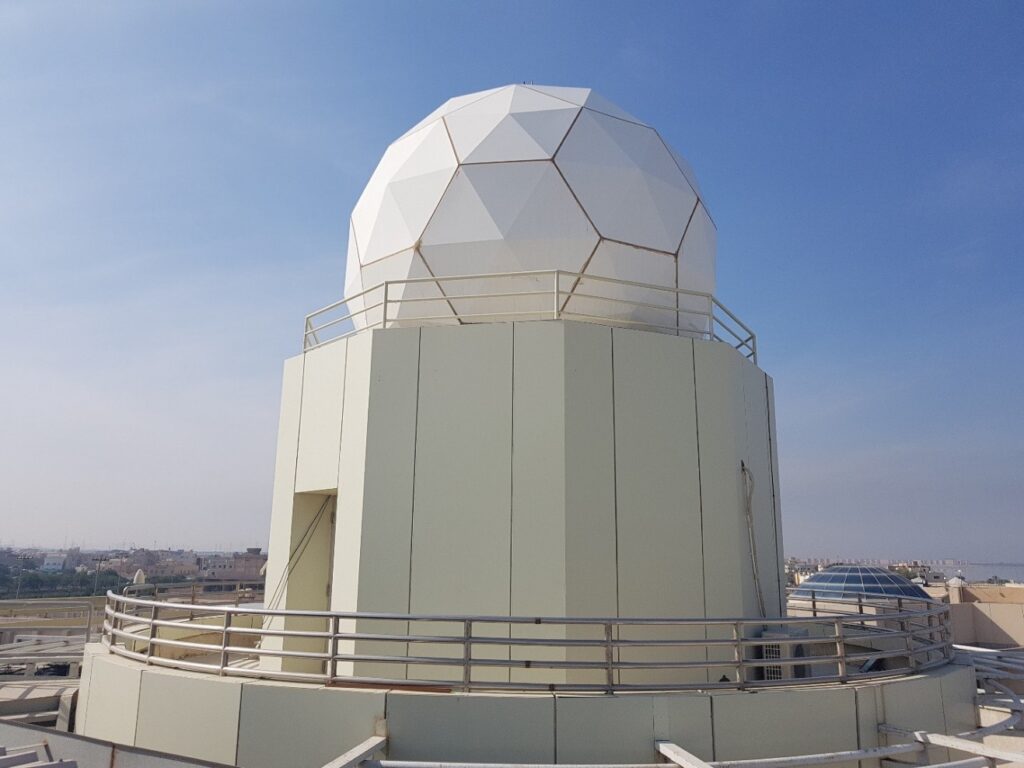
The new weatherproof radome protecting a 3-meter reception antenna of ROPME’s X-band Station which has installed in Granada (Ghornata) area, Kuwait in May 2018.
ROPME Earth Observation Receiving Station
This Station has been installed in ROPME’s new Headquarters in Granada in Kuwait for purpose of scheduling, receiving, processing, visualization, analyzing and archiving X-band direct broadcast data and live satellite images from available earth observation satellite platforms. Currently, the station receives data from 4 different earth observation satellite platforms (NASA’s Terra, Aqua, Suomi-NPP & NOAA-20) on daily basis during day and night in a real-time mode. The processed data and image products are utilized for operational marine environmental monitoring and rapid response to coastal and marine hazards. The ground station is also designed to be easily upgradeable for receiving data from other X-band satellites, such as Chines EO, FengYun-3B (FY-3B) platform.
This station, like its predecessor one, serves as the leading and top operated ground station in the ROPME Sea Area, as it operates 24 hours a day, seven days a week and freely distributes satellite data primarily to the concerned environmental authorities and stakeholders in the region. The coverage area and footprint of the ROPME ground station is about 25 million square km (within a radius of up to 2800 km of the station site). Accordingly, this station can acquire a satellite image not only covering the ROPME Sea Area, but also distant areas like Caspian Sea, Red Sea, eastern Mediterranean and Black Sea (see attached coverage map), if needed.

Satellite-derived data and parameters processed by this Station on daily bases, include among others: sea surface temperature (sst), chlorophyll concentration (chl-a), turbidity indicator (kd490), color dissolved organic matter (CDOM), backscatter and absorption coefficients. Traditional true and false color image composites are also being produced.
Data received and processed are being used for routine assessment of coastal water quality and state of the marine environment, and early warning of the risks of emerging hazards such as HABs, dust storms and marine oil spills emerged in the ROPME Sea Area.
Components & Equipment of the Station
The station system comprises the following principal components:
I. X-Y Tracking Antenna System (Outdoor equipment)
It includes X-band (7.7 – 8.5 GHz) auto-tracking 3m dish antenna (reflector) made of carbon fiber, rotator, controller, RF components, GPS antenna, X-band feed, LNA and downconverter; all housed in a protective 5.0 m x 5.5 m weatherproof radome over the top of ROPME’s new building in Granada, Kuwait.
This system also includes a full package of antenna control software with all aspects of antenna operation monitoring and control.
II. Control Unit (Indoor equipment)
It includes a modular X-band receiver rack, demodulator, UPS, ingest and data capture PC (acquisition) and processing and visualization PC, as following.
1. X-Band Receiver:
The X-Band satellite receiver includes a 4U rack-mount configurable multi-mission satellite demodulator and bit-synchroniser capable of handling the various demodulation and bit-synchronisation schemes, necessary to receive data from EO satellites (Aqua & Terra, NPP & JPSS, and Feng Yun 3).
2. X-Band Acquisition System:
The X-band data acquisition system is a high specification, Linux based PC workstation, with hardware and software to schedule, track, receive and ingest data from these satellites and maintains a rolling archive of level-0 data on disk. It also includes a simulcast from NASA with a quick-look viewer to follow acquisition of images and assess quality of the received images in a real-time mode.
3. X-Band Processing System:
The X-band data processing system is a high specification, Linux based PC workstation with hardware and software to generate level-1B and level-2 data products from the received data, import, process, visualise and export these data.

Hierarchy and concept of work of ROPME X-band reception Station.
The hierarchy of work of the station starts first with reception of the real-time MODIS or VIIRS raw data through the Direct Broadcast capability of ROPME Ground Station, which then are processed in timely manner using standard methods and algorithms to higher-level data and products including quick look images, thematic maps, etc. In case of any marine incident or hazard, the remote sensing experts at ROPME issue an alert to ROPME’s Marine Emergency Mutual Aid Centre (MEMAC) and the concerned national focal point of the Member State to react and response.
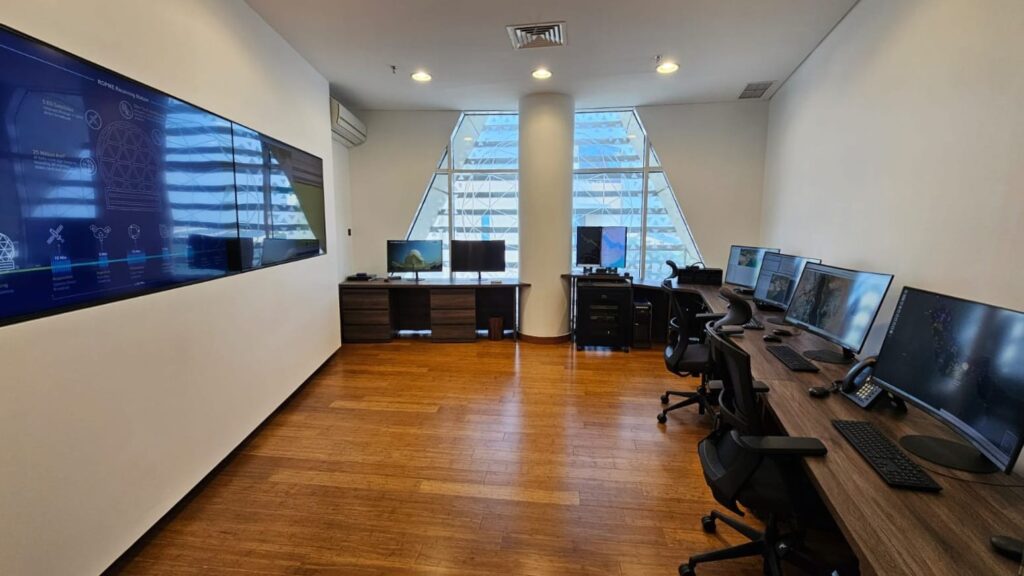
A panoramic view for the control unit of the new ground receiving station at the new ROPME’s Headquarters in Granada area, Kuwait.
Satellite Data Products:
Standard data products processed by ROPME Station from daily received MODIS and VIIRS passes include, among others, sea surface temperature (SST), chlorophyll concentration (Chl-a), turbidity indicator (kd490), color dissolved organic matter (CDOM), backscatter and absorption coefficients. Traditional true and false color image composites showing clouds and dust coverage, vegetation cover and other major features and land-cover / land-use patterns at 250 m to 500 m spatial resolution are also being produced on daily bases.
Most of these data products are delivered after 35 – 45 minutes of completion of their reception in hdf format but they can also be supplied in GeoTIFF or other standard formats for assimilation by GIS systems.
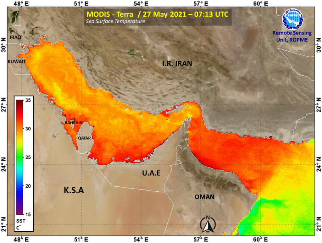
Satellite–retrieval of sea surface temperature (SST) as processed by the RSU at ROPME from MODIS-Terra data acquired on 27 May 2021

Satellite-retrieval of chlorophyll-a concentration (Chl-a) in the ROPME Sea Area, as processed by the RSU at ROPME from MODIS-Aqua data acquired on 27 May 2021
These data are occasionally validated using in-situ measurements supplied intermittently from the national focal points or sometime though field check using traditional observations or available remote sensing instruments like hand held spectrometer.
In addition to archiving the near real-time data received from MODIS and VIIRS, the RSU also holds an extensive archive of satellite data from other sensors e.g. Landsat, DMC-II, Sentinel-1, and Sentinel-2.
Services and Functions:
Satellite data received and processed by the RSU is essential for real-time monitoring of coastal hazards and unusual marine phenomena / incidents in the ROPME Sea Area.
These data are routinely used in number of applications such as assessment status of the marine environment and monitoring risk of oil spills, HABs, cyclones, dust storms and other hazards. Measuring of ocean surface temperature is also very important for detection of upwelling areas and other dynamic features.
Products of these data are therefore essential and very critical for providing a regional and local environmental management information to concerned environmental authorities and ROPME national focal points to enable them for taking a sound decision-making in critical applications, e.g. monitoring of oil spills, harmful algal blooms, dust storms, cyclones, etc.

An example for one of the image final product of ROPME Station showing massive algal bloom in the Middle ROPME Sea Area sent with information alert to concerned ROPME NFPs in Iran, Oman, and UAE.
The RSU is also concerned with development of methodology and integrated tools for monitoring and assessment of marine and coastal environments and emerging hazards by satellite remote sensing. In this context, the RSU welcome proposals from interested organizations and partners to jointly develop applications of remote sensing data for marine environmental monitoring.
ROPME through its RSU also organizes from time to time remote sensing training courses to young marine researchers and specialists who are involving in satellite-based environmental monitoring or/ and coastal zone management. This training aims to improve scientific and technical skills in the field of satellite image processing and application of remote sensing data on the ROPE Sea Area e.g. in assessment state of the marine environment, mapping of coastal habitats, trajectory of oil spills and dust storms, etc.