
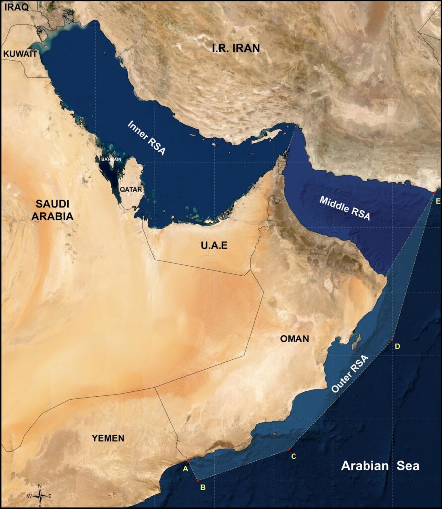
The ROPME Sea Area (RSA) covers a nearly 500,000 square kilometer semi-enclosed marine region that lies between 15°N to 30°N latitude and 47°E to 61°E longitude. This vast area spans the coastal and offshore waters of eight Member States: Bahrain, I.R.Iran, Iraq, Kuwait, Oman, Qatar, Saudi Arabia, and the United Arab Emirates.
ROPME’s definition of the RSA is rooted in the Kuwait Regional Convention (1978), and according to Article II, the ROPME Sea Area (RSA) is defined as extending between the following geographic latitudes and longitudes, respectively:
A – 16°39’00”N, 53°03’30”E
B – 16°00’00”N, 53°25’00”E
C – 17°00’00”N, 56°30’00”E
D – 20°30’00”N, 60°00’00”E
E – 25°04’00”N, 61°25’00”E
Due to the ROPME Sea Area’s (RSA) wide range of environmental, hydrological, and geomorphological conditions, the region has been subdivided into three distinct sections to better support monitoring, analysis, and management efforts.
The Outer RSA (112,625 Km²) represents the southernmost part of the region, covering the offshore Omani waters up to 70 nautical miles from the coast.
The Inner RSA (236,165 Km²) extends from the Shatt Al-Arab estuary in the northwest to the Strait of Hormuz, encompassing shallow, hypersaline waters with limited circulation and significant riverine influence.
The Middle RSA (113,147 Km²) refers to the Sea of Oman, characterized by deeper waters, enhanced connectivity with the Indian Ocean, and more dynamic circulation.
RSA Exclusive Economic Zone
In accordance with the United Nations Convention on the Law of the Sea (UNCLOS), each coastal State within the ROPME Sea Area (RSA) is entitled to establish an Exclusive Economic Zone (EEZ) extending up to 200 nautical miles from its baselines. However, due to the semi-enclosed nature of the RSA and the proximity of the eight Member States’ coastlines, the full 200-nautical-mile extension is not feasible in most areas. Instead, maritime boundaries are delimited based on equidistance principles or bilateral agreements.
Despite these legal boundaries, the RSA functions as a highly interconnected marine system. Water masses, currents, and ecological processes do not consider jurisdictional lines, meaning that environmental challenges such as pollution, algal blooms, and oil spills often transcend EEZs.
This reality reinforces the importance of cooperative regional governance under ROPME, where all Member States recognize the shared nature of their marine space and the mutual responsibility for its protection.